Walk of a lifetime: Cadair Idris
Click here to donwnload this walk
Of all the mountain routes in Britain, I defy anyone to name one with more bang for your buck than the classic Cadair Idris horseshoe. Relatively short, it can be done in half a day. In winter it becomes a comfortable day route. And in high summer, if you’re keen, it can be completed in an evening. The drug of happiness is addictive, and this walk exudes it. However you do it, you will return.
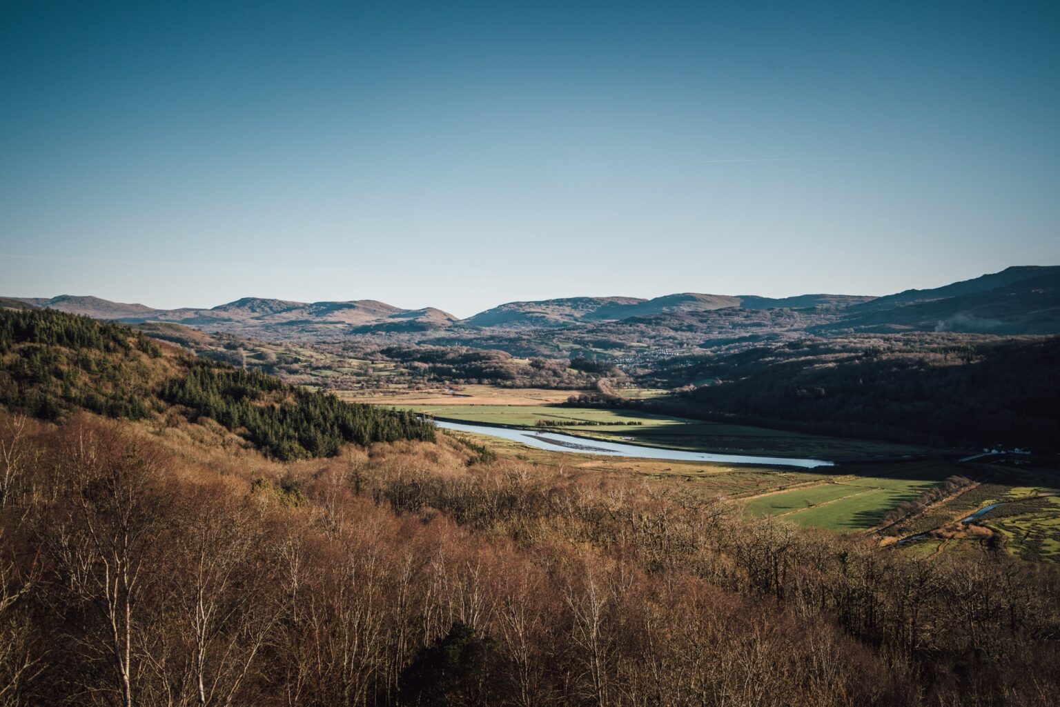
Right, let’s get started. Leaving the car park on the south-east side of the mountain (map point 1, grid ref SH731115), follow signs for the Cadair Idris Walk. The loos, nature reserve signs and café are all soon behind you as the uphill begins. The path is easy to follow and starts to climb through an area of mixed woodland, pine, oak and birch, rich with birdlife in spring, with pied flycatcher, redstart and wood warbler being a few of the summer migrants encountered.
This woodland is a fragment of what was once the covering for all lower mountain slopes in Britain. Fresh from the car, its purity removes any stress. A small pair of binoculars would be a good addition to your kit list for the day. The trees thin, the contours widen and the view opens. You’ll reach a slate bridge over Nant Cadair (point 2, SH727120). Remember this horizontal monolith; you’ll return that way later. Keep the river on your right and follow the wide, well maintained mountain path westwards into the beating heart of the Cadair Idris National Nature Reserve.
You’ll feel like you’re being watched. The further towards Llyn Cau you move, the more you feel as if you’re about to be swallowed. Ignore the main track for the moment as it swings up the northern flanks of Craig Lwyd, and head for the shores of the llyn (point 3, SH717124). Once there, stoop down and cup the waters in your hands, splashing your face, cleansing yourself with the very lifeblood of the mountains.
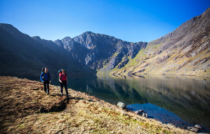
Gazing upwards, the huge rock walls to your south and west look like collapsed books on a shelf, revealing a jagged skyline. It’s from here the evaporating waters on your cheeks came. Spend as much time as you need, and look for peregrines and ravens. If you’re here in spring and summer you will have already seen a few wheatear, that small bird of the uplands with the conspicuous white ‘arse’.
As time waits for no one, your moment of solace with the mountain and its inhabitants must come to an end, for we’re only a quarter of the way through the route. From Llyn Cau, turn back east-south-east and regain the main track up Craig Lwyd. Short and sharp but, oh my, with every step the view of the llyn and Cadair’s true summit Penygadair gets better and better. The quality of this mountain day is really starting to show.
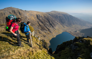
This high, rough section of the Minffordd Path climbs westwards. Great slabs to your north often obscure the view that way, but gaze to the south and see the hills of mid-Wales stretch far and wide. On your clockwise route above Llyn Cau, the pyramidal east face of Craig Cwm Amarch is unmissable. You’re now viewing the mountains at eye-level. You no longer need to tip your head back, you are among them.
The path veers north, handrailing the crags, climbing the last few metres to cross a ladder style and depositing you on the sheer east summit of Craig Cwm Amarch (point 4, SH710121). A small patch of turf marks the summit, plunging vertically to the slate/blue llyn below. The Mynydd Pencoed ridge snakes off south-west, one of the three main ridge systems that make up the Cadair Idris range.
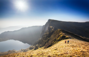
Continuing clockwise, the path descends north-north-eastwards, exposing momentary views to the east, vertically down towards the llyn. Once at the low point of Craig Cau, Penygadair looks close, but the mountain here lays back more than you might expect, so ration your energy wisely. This is the last real climb of the day.
Two things happen on the ascent of our 893m high target. The first is the views back to our first peak become gut-churning as you realise where you were just standing. The second is impressive in a different way – pillow lava. Rock, in great turd-like heaps, sits on the shoulder of this mountain giant. There is no mistaking the shapes – you can imagine the lava erupting on the sea bed, cooling instantly. The south-west approach to the summit of Penygadair is about as good as it gets.
The views westwards take in Llyn y Gadair and the peak of Cyfrwy, the right-hand edge of which is the sensational Cyfrwy arête, where ropes are needed on a Diff rock climb. Beyond this is Barmouth and the sea. In fact, it’s at this point you’d be forgiven for abandoning the route and steering hedonistically towards the golden sands. There is something about mountains near the coast, and this view, on a sunny day, will lodge in the memory forever.
We inevitably come to the summit (point 5, SH710130). The views are wide and far, with Snowdon visible to the north. There is a well-known legend that if you spend a night on the summit, you will return in the morning as either a poet or a madman.
A few metres to the north-east of the trig point is a low stone-built shelter. This makes a great place for a bad-weather lunch break. It has benches aplenty inside, although small windows make it a little gloomy. I spent a night there a few winters ago. The snow outside had melted, but inside five inches of ice covered the stone floor. If you’re here in darkness then be aware of the cliffs to the north-west of the summit – they have claimed lives.
Leave the summit in a north-easterly direction, and there’s a clear path which leads to our third and final peak of Mynydd Moel. Handrail the cliff edge all the way, because the views will be far more epic. There is a point near Mynydd Moel where the views back towards Penygadair seer themselves onto the retina, with jutting rocky outcrops on the ridge compressing into a mountain scene with serious swagger.
Passing through a fence line that descends south-south-east, reach the summit of Mynydd Moel (point 6, SH727136). Here a rock ‘nest’ gives shelter on a bad day. This is my favourite place on the route, as looking south-west you can see the Cadair Idris massif in all its glory. Return to the fence, follow it south-south-east. Losing over 400m in vertical height, it fast-tracks
you off the mountain. From a point on this descent, the view to the south-west into Llyn Cau was made famous in 1765 when the artist Richard Wilson produced a wondrously dramatic painting that kept artists and tourists frequenting these mountains for centuries.
Keep your eyes and ears open while you’re here, as it’s a great place to see jets tearing through the valley below, before banking hard to the south and pulling up and out of the ‘Mach Loop’ (a circuit of southern Snowdonia regularly used for low-level mountain flying).
A path cuts across the fence line (point 7, SH732124). Turn right onto it, heading south-west. Nant Cadair will be below you and the slate bridge passed earlier will soon be reached. Now retrace your steps to the start of the walk.
WHERE DO I START?
The Cadair Idris National Nature Reserve pay and display car park (Grid ref SH731115).
WHAT’S THE TERRAIN LIKE?
You get a real mixture on Cadair Idris, including valley path, steep rocky trail, mixed woodland, open corrie, mountain lake, broad and high mountain ridge, exposed col, rocky summit, and grassy slope.
HOW HARD IS THE WALK?
Cadair Idris is a challenging mountain walk, but the terrain isn’t technical so all you need is decent fitness, good outdoor gear, and solid navigation skills.
WHAT MAP SHOULD I USE?
The OS Explorer OL23 map covers the whole route in 1:25,000 scale, as does the Harvey Superwalker: Snowdonia Cadair Idris.